Considerations for bikepackers- Day 1:

Akureyri to Skjálfandafljót riverbank (80km)
- Which part of the route was the hardest? I mean this “objectively” because I try to remove emotions or factors such as riding onto a patch of the road at the end of the night, which it might be hard due to tiredness, etc. Therefore, in comparison to what comes next, this entire route is OK, unless you really do not like hills. There is long hill on tarmac 20km outside Akureyri.
- Get it right from the start. One might argue, we should had arranged for an extra day as a prep, or had fully prepared the bikes the previous night. Starting as early as possible on your first day, makes a lot of sense, especially if you want to do the Akureyri to Botni segment in one day. It is certainly feasible, but you better start early in the morning. My bag system was a combination of products from Apidura, Aeroe, Tailfin and Ortlieb. Despite our test rides, or rather, because of them, I ended up reaching to the ideal setting in the very day of our departure. Not ideal.
- Mountain biking is a markedly different beast. Yes, yes, I state the obvious, but I really did not consider it that much. Previously, I mainly had four rides with my Whyte 909 hardtail under my belt, therefore we evidently underestimated the distance-per-hour we could ride at best of times. A 110km ride with 1120m of elevation (our planned first ride), even when half of it was on asphalt, was a bit off the mark in terms of what we could have realistically achieved in a day, which includes prepping the bikes in the morning, and messing about with our GPS. This is pertinent especially considering the difficulty of the second half of the ride, as well as the ability to sustain high speeds whilst riding a 50kg bike, including gear and supplies, over a very varied terrain. If we had started the ride at 8am, things might have been different.
- Bottles in cages. Well, be prepared to lose one or two, considering the terrain. We used the awesome Tailfin cage system for the suspension which mounts two bags and two bottles. Make sure they fit tightly. We both lost bottles.
Considerations for bikepackers – Day 2:
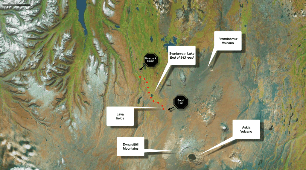
Skjálfandafljót riverbank to Botni Hut (34km)
- Which part of the route was the hardest? Precisely 6km before Botni is the signposted point, where the road splits. Those 6km that you need to cross to reach Botni are the hardest. I practically wrote a whole fucking essay in the main page to emphasise this.
- Get a small filtration system with you. We brought one with us (Platypus QuickDraw), almost reluctantly. For some reason, a few blogs highlighted how easy it is to get water from natural water sources, but frankly, we heard differently things once we were there, and also we got to use ours for a good reason more than a few times. We also had 4 x 2 litres Hydrapak Reservoirs with us, which they take very little space when they’re collapsed, but super useful to carry extra water with when needed.
- You really don’t need too many pots and pans. Oh my God. Firstly, we really really didn’t need a bloody cafetiere (instant next time!). What was I thinking. Although we had a good arrangement – Josh preparing all the Firepot meals (payback from all the meals I cooked for him in the past), and I would do the dishes – I hated it so much. Why didn’t I just believe in all these utopian photos of ethereal smiley people, bike-packers out in the wild, with ecstatic disposition, eating straight from their dry-food packaging? No, I wanted to take environmentally conscientious approach, and buy meals mostly in compostable packaging, meaning you can’t pour boiled water directly into the package. Unfortunately that didn’t work out very well. Our powerful Primus Omnilite stove was speeding things up only to end up scraping food from the pots and plates (burnt-fucking-porridge!) for ages, whilst occasionally not having enough water for such task and being knackered after a hard-day’s ride, etc, – for me, this experience ended up to be considered up there, with riding uphill over scores of fucking volcanic rocks, in terms of mental anguish.
Considerations for bikepackers – Day 3:
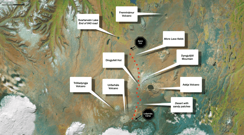
Botni hut to Urðarháls foothills (63km)
- Which part of the route was the hardest? There are around 60km distance between Askja lake/caldera (clearly visible on the map) and the edge of Urðarháls where we camped. Although there is sand throughout this desert, the hardest part was roughly 20km before we had reached the edge of Urðarháls. In that there are some twists and turns, and small hills, where the sand complicates things. We did it mostly in the dark, but I feel you should be careful, and avoid speeding, because there are “sandpits” at the bottom of some of those (small) hills.
- Oh, what to do in one’s spare time, what to do. Well, fuck all, that’s what you would want to do. This worst-case-scenario approach in planning can get out of hand, as I bought a kindle and myriads of e-books I never got to read; I was envisioning heavy storms that would last for hours/days, and me, isolated in a tent, so what would I want to do with my time. Crashed out from exhaustion? And there were no such storm situations anyway. And if there were any, I suppose I would have written this bog, and sleep more.
- Do I need a backpack? I avoided carrying backpacks in all my previous tours, worrying it would weigh heavily on my back/neck. This time, I brought with me my packable ultralight Matador, in case of emergencies. Well…I used it from day one and throughout the journey, and it was a lifesaver for so many reasons, even when I started having more space in my bike bags, as we were consuming the consumables.
- Do you even know what Down Pants are? I never knew they existed, and yes, there is nothing better to protect you in the highland desert night than marshmallow man pants. I loved mine (Nanga-Gramicci). You need some in your life, as I use them all the time now.
Considerations for bikepackers – Day 4:
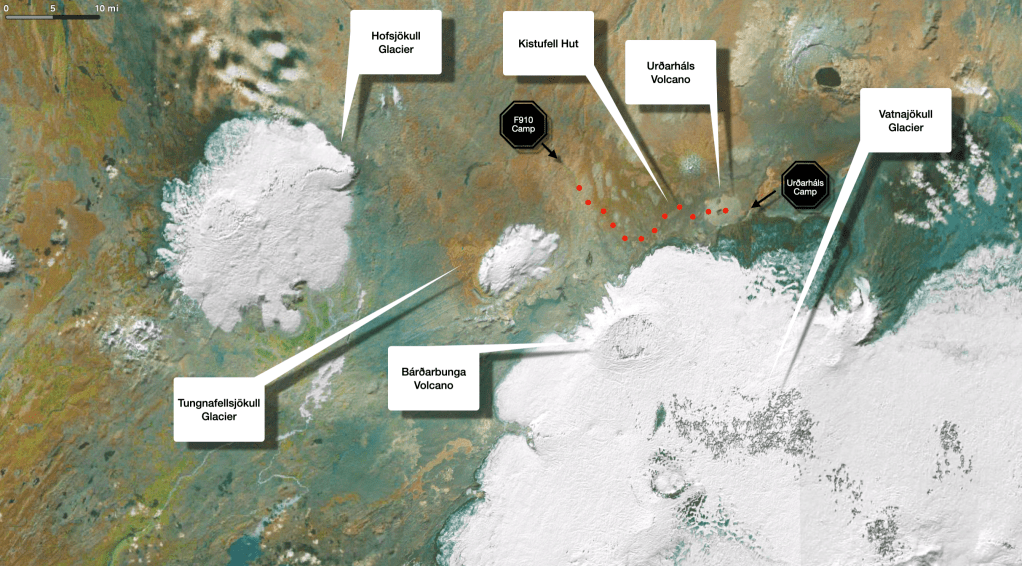
Urðarháls foothills to F910 Crossroad (38km)
- Which part of the route was the hardest? Going up the Urðarháls.
- Managing emotions in such conditions is hard. The whole viability of such tours is depended on the efficacy of the relationship you have with your cycling partner. I may not be the most technical individual, but I have my uses, enough so hopefully Josh does not feel like he has to “carry” me. I can get frustrated when faced with small inconveniences, but conversely Josh might seem like the world is about to end, if we are faced with a tad more serious challenge. Ok, his behaviour is probably more normal than mine, but at least they compliment each other, i.e. one of us usually remains level-headed and ready to rationalise, take over and calm the situation down. We are ready to consider each others’ feelings, empathise and look after each other. We are also ready to anticipate situations, and be easy-going in terms of changing decisions and planning. Anyway, in summation, bloody well know the person you are doing such tours with.
Considerations for bikepackers – Day 5:
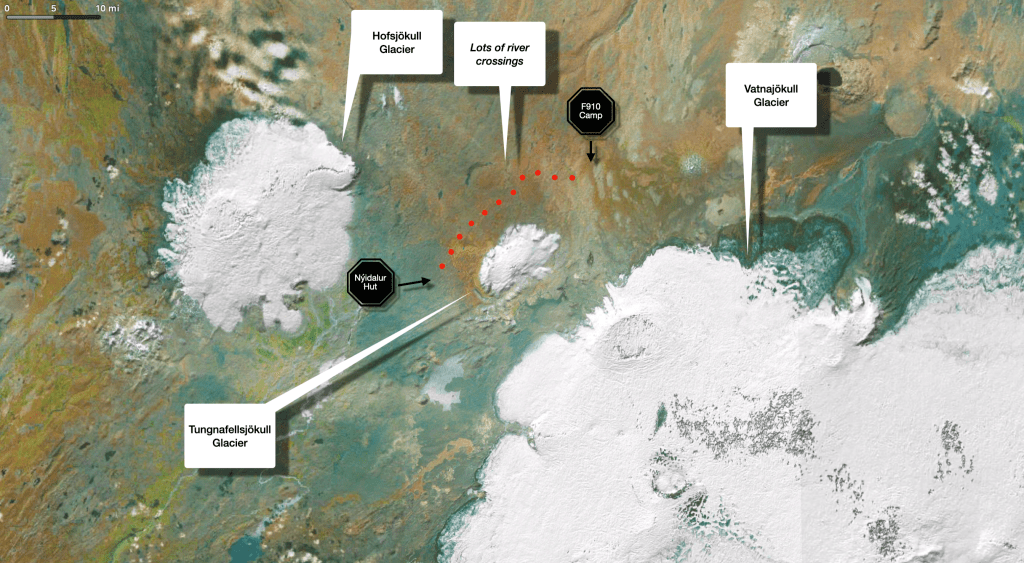
F910 crossroad to Nýidalur Hut (28km)
- Which part of the route was the hardest? We were lucky with the river crossings, but around 20km before we reached Nýidalur there were some of the widest and deepest of them, but as I mentioned before, none were as dangerous as we had anticipated for, and that was surely down to the weather. I would say, be well prepared for getting wet up to your waist for sure, but if the weather is uglier, then, I have no idea. How you protect and carry your stuff will also be important. You could also look harder for the least deep/wide part of the river, even if it means you go off route, to avoid anything like deeper than the waist.
- Do I really need sandals? Yes you do. Merrell’s Hydro Moc are rubbery and incredibly versatile. It might seem weird to cycle with them, but for a while, I continued riding in them after we had finished with the rivers. Also, I used fully waterproof socks with them once, but you need to be sure of the depth of the river you are crossing. Mine got wet and they took ages to dry up.
Considerations for bikepackers – Day 6:
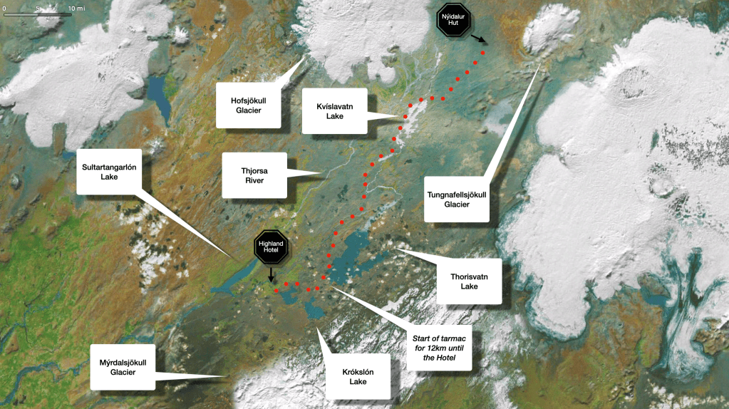
Nýidalur Hut to Highland Centre Hotel (111km)
- Which part of the route was the hardest? There were snippets of hardships dotted throughout the day, occasional “speed bumps”, hills and rough gravel, but nothing long and distinctive that stands out. At some point immediately after we had passed lake Kvislavatn, on top of a hill, we arbitrarily decided to turn right and take another detour through some serious sandy paths and narrow gravel. Well, it was beautiful and even more remote, but I would not recommend it. We sustained it only for 3km, before we ignominiously turned back to rejoin the main road. Therefore in general, all of those gravel roads on this day’s ride, were infinitely better than the elusive paths we occasionally encountered as we were crossing the various lava fields earlier on our journey..
- Highland Centre Hotel is great. It might not be as obvious choice to stay when one is doing research for the divide. If you don’t stay the night though, you can get some supplies there from their mini-grocery shop and stock up properly for the rest of the ride, even if you take the longer route and go around and towards Vik in the east.
Considerations for bikepackers – Day 7:
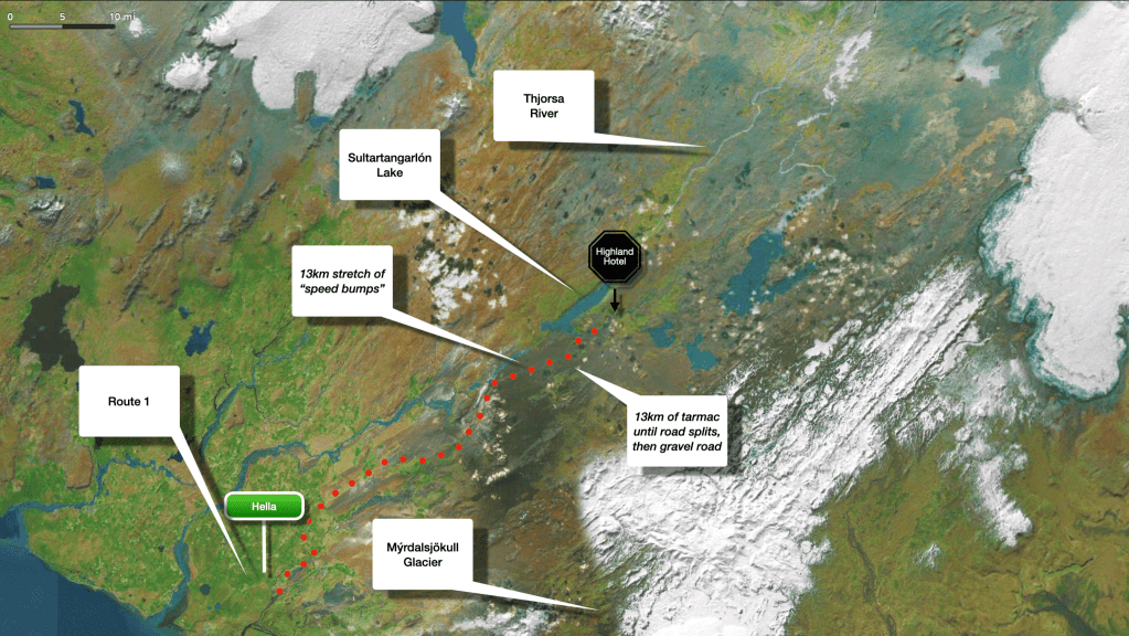
Highland Centre Hotel to Hella (81km)
- Which part of the route was the hardest? 13km after the Highland Hotel, when the F26 continues into this utterly diabolical gravel road with those “speed bumps” I described earlier on. This lasts for around 13km, and even cars had to go with less than 10km per hour, due to the wavy nature of the road. In fact, there was a family in a car I distinctly remember, barely moving towards us from the opposite direction, stopping to grovel about their experience only to give us some spectacularly false hope by vastly understating the distance they had just covered on this gravel road, thus when we realised it was much more what they had estimated on their advice, my misanthropic tendencies resurfaced, momentarily notwithstanding. (What a pompous sentence, eh? Oh, well)
- Here is a slightly different route option. 42km before you reach Hella, you could turn to 268, a quieter and nicer route to reach R1, and shorter by 4km than the F26/271 we stayed on. Having said that, it was the last leg of our trip, and we really, and I mean really did not wish to encounter any of those natural speed bumps we experienced before, considering it was a gravel road and how fucking knackered we were! That photo in the main page, with Josh by the Hella sign, is that moment of contemplation, whether we should turn or not.
- Ending the tour in Vik. It would probably really worth it to take the route around Mýrdalsjökull towards the east and end the trip to Vik, as per our initial plan, especially since Vik, with all due to respect to the residence of Hella, is much more picturesque. Having said that, the way out of Vik and back to Reykjavik would almost certainly mean another day’s worth of travel, either by staying the night there and leave in the morning with a bus (if you can get the bikes in the bus, as others complained that might not be a given), or by cycling to Bakki airport, 75km west, to get a car rental, as we initially had planned.
- Have a back-up phone. If you can get hold of another smartphone and have it ready set up with your details etc and hidden away in your bags, can be very useful. We always do that in our rides. This time Josh broke his phone, so he got to use the back up one.
- Is there network signal in the highlands? We were warned that there will be none, but there were patches of connectivity throughout our journey, much more than we had expected. We were also equipped with a satellite communicator (Garmin InReach Mini 2), which was great for back up, and for our folks back in the UK to track our progress in Garmin’s website.
